
Faýl:South America laea relief location map.jpg

Bu synlawyň ölçegi: 409 × 600 piksel. Other resolutions: 163 × 240 piksel | 327 × 480 piksel | 524 × 768 piksel | 1 181 × 1 732 piksel.
Original faýl (1 181 × 1 732 piksel, faýlyň ölçegi: 1,71 MB, MIME tipli: image/jpeg)
Gysgaça düşündiriş
| Düşündiriş |
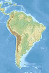
English: Relief location map of SouthAmerica.
|
| Sene | |
| Çeşme | Öz işi (eseri) |
| Awtor | Uwe Dedering |
Lisenzirleme
I, the copyright holder of this work, hereby publish it under the following licenses:
Bu faýl Creative Commons Attribution-Share Alike 3.0 Unported lisenziýasyna laýyklykda lisenzirlenendir.
- Siz erkin:
- paýlaşyň – iş göçüriň, paýlaň we gowşuryň
- goşuşdyryp dörediň – iş adaptirläň
- Aşakdaky şertlere laýyklykda:
- salgylanma – Esere awtor ýa-da lisenziýa eýesi tarapyndan görkezilen (ýöne sizi ýa-da eseri ulanmaklygyňyzy goldaýandyklaryny öňe sürmeýän) görnüşde salgylanmalydyr.
- meňzeş paýlaşma – Bu eseri üýtgeden, öwüren ýa-da bu esere esaslanýan başga bir eser döreden ýagdaýyňyzda, emele gelen eser üçin diňe şu ýa-da şuňa meňzeş lisenziýany ulanmak arkaly paýlap bilersiňiz.

|
Permission is granted to copy, distribute and/or modify this document under the terms of the GNU Free Documentation License, Version 1.2 or any later version published by the Free Software Foundation; with no Invariant Sections, no Front-Cover Texts, and no Back-Cover Texts. A copy of the license is included in the section entitled GNU Free Documentation License. |
Islän lisenziýaňyzy saýlap bilersiňiz.
Faýlyň taryhy
Faýlyň geçmişini görmek üçin Sene/Wagt bölümündäki senelere tyklaň.
| Sene/Wagt | Miniatýura | Ölçegler | Ulanyjy | Teswir | |
|---|---|---|---|---|---|
| häzirki | 12:50, 27 noýabr 2010 | | 1 181 × 1 732 (1,71 MB) | Uwe Dedering | {{Information |Description={{en|1= Relief location map of SouthAmerica. * Projection: Lambert azimuthal equal-area projection. * Area of interest: :* N: 25.0° N :* S: -60.0° N :* W: -90.0° E :* E: -30.0° E * Projection center: :* NS: -17.5° N :* WE: |
Faýlyň ulanylyşy
Bu faýly ulanýan hiç hili sahypa ýok.
Global faýl ulanyşy
Bu faýl aşakdaky beýleki wikiler tarapyndan ulanylýar:
- als.wikipedia.org sahypasynda ulanyş
- ar.wikipedia.org sahypasynda ulanyş
- ast.wikipedia.org sahypasynda ulanyş
- av.wikipedia.org sahypasynda ulanyş
- azb.wikipedia.org sahypasynda ulanyş
- az.wikipedia.org sahypasynda ulanyş
- And dağları
- Amazon çayı
- Robinzon Kruzo adası
- Aleksandr Selkirk adası
- Santa Klara adası
- Kopaue
- Şablon:Yer xəritəsi Cənubi Amerika
- İquiqe zəlzələsi (2014)
- İquasu Milli Parkı (Argentina)
- İquasu (şəlalə)
- Serra-du-Mar
- Magellan boğazı
- Dreyk boğazı
- Biql boğazı
- Valdivia zəlzələsi (1960)
- Grau dənizi
- Argentina dənizi
- Pataqoniya arxipelaqı
- Qalinas burnu
- Frоuаrd burnu
- Parinyas burnu
- Seyşas burnu
- Tietе
- Quayra şəlaləsi
- Lyulyaylyako milli parkı
- Kabu-Branku burnu
- Moça adası
- Benxamin adası
- Quamblin adası
- Ceyms adası (Çili)
- Viktoriya adası (Çili)
- Kuptana adası
- Melçor adası
- Rivero adası
- Trayqen adası
- San Ambrosio
- Doson adası
Bu faýlyň global ulanyşyny görkez.