
Faýl:Azerbaijan location map.svg

Size of this PNG preview of this SVG file: 512 × 392 piksel. Other resolutions: 314 × 240 piksel | 627 × 480 piksel | 1 003 × 768 piksel | 1 280 × 980 piksel | 2 560 × 1 960 piksel.
Original faýl (SVG faýly, nominal 512 × 392 piksel, faýl ölçegi: 156 KB)
Gysgaça düşündiriş
| Düşündiriş |
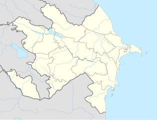
English: Location map of Azerbaijan. Borders of 1994-2020
Equirectangular projection. Strechted by 131.0%. Geographic limits of the map: * N: 42.0° N * S: 38.2° N * W: 44.5° E * E: 51.0° EMade with Natural Earth. Free vector and raster map data @ naturalearthdata.com. |
| Sene | |
| Çeşme | Öz işi (eseri) |
| Awtor | Uwe Dedering, Don-kun |
| Beýleki wersiýalar |
|


Lisenzirleme
I, the copyright holder of this work, hereby publish it under the following licenses:
Bu faýl Creative Commons Attribution-Share Alike 3.0 Unported lisenziýasyna laýyklykda lisenzirlenendir.
- Siz erkin:
- paýlaşyň – iş göçüriň, paýlaň we gowşuryň
- goşuşdyryp dörediň – iş adaptirläň
- Aşakdaky şertlere laýyklykda:
- salgylanma – Esere awtor ýa-da lisenziýa eýesi tarapyndan görkezilen (ýöne sizi ýa-da eseri ulanmaklygyňyzy goldaýandyklaryny öňe sürmeýän) görnüşde salgylanmalydyr.
- meňzeş paýlaşma – Bu eseri üýtgeden, öwüren ýa-da bu esere esaslanýan başga bir eser döreden ýagdaýyňyzda, emele gelen eser üçin diňe şu ýa-da şuňa meňzeş lisenziýany ulanmak arkaly paýlap bilersiňiz.

|
Permission is granted to copy, distribute and/or modify this document under the terms of the GNU Free Documentation License, Version 1.2 or any later version published by the Free Software Foundation; with no Invariant Sections, no Front-Cover Texts, and no Back-Cover Texts. A copy of the license is included in the section entitled GNU Free Documentation License. |
Islän lisenziýaňyzy saýlap bilersiňiz.
Faýlyň taryhy
Faýlyň geçmişini görmek üçin Sene/Wagt bölümündäki senelere tyklaň.
| Sene/Wagt | Miniatýura | Ölçegler | Ulanyjy | Teswir | |
|---|---|---|---|---|---|
| häzirki | 16:48, 10 ýanwar 2024 | | 512 × 392 (156 KB) | Janitoalevic | Economic Regions |
| 08:09, 5 maý 2016 |  | 1 200 × 919 (227 KB) | Rs4815 | Reverted to version as of 16:20, 21 April 2016 (UTC) | |
| 22:22, 3 maý 2016 |  | 1 200 × 919 (217 KB) | Taron Saharyan | нет достоверных данных, вы переместили границу на 1 км. чуть ли не по всей линии, это бред | |
| 16:20, 21 aprel 2016 |  | 1 200 × 919 (227 KB) | Don-kun | fix karabakh border | |
| 09:46, 17 aprel 2016 |  | 1 200 × 919 (227 KB) | Don-kun | fix border to karabakh | |
| 16:46, 13 aprel 2016 |  | 1 200 × 919 (217 KB) | Don-kun | Jojug Marjanli now to Azerbaijan (region seemed to be a bit wrong before ...) and tried to fix some other parts of NKR-AZ-Border | |
| 19:43, 7 iýun 2010 |  | 1 200 × 919 (217 KB) | Don-kun | correct borders of rayons; hole area under karabakh control, not the former Nagorno-Karabakh Autonomous Oblast | |
| 13:11, 19 fewral 2010 |  | 1 200 × 919 (244 KB) | Uwe Dedering | Nagorno-Karabakh not grey, but visible | |
| 17:58, 18 fewral 2010 |  | 1 200 × 919 (244 KB) | Uwe Dedering | but really with dagestan | |
| 17:42, 18 fewral 2010 |  | 1 200 × 919 (233 KB) | Uwe Dedering | Dagestan and parts of Armenia saved from drowning, Nagorno-Karabakh now under the region-borders. |
Faýlyň ulanylyşy
Bu faýly ulanýan hiç hili sahypa ýok.
Global faýl ulanyşy
Bu faýl aşakdaky beýleki wikiler tarapyndan ulanylýar:
- bn.wikipedia.org sahypasynda ulanyş
- ckb.wikipedia.org sahypasynda ulanyş
- de.wikipedia.org sahypasynda ulanyş
- fy.wikipedia.org sahypasynda ulanyş
- he.wikipedia.org sahypasynda ulanyş