
Faýl:Territorial Expansion of Greece from 1832–1947.gif
Bu synlawyň ölçegi: 800 × 575 piksel. Other resolutions: 320 × 230 piksel | 640 × 460 piksel | 868 × 624 piksel.
Original faýl (868 × 624 piksel, faýlyň ölçegi: 49 KB, MIME tipli: image/gif)

|
This map image could be re-created using vector graphics as an SVG file. This has several advantages; see Commons:Media for cleanup for more information. If an SVG form of this image is available, please upload it and afterwards replace this template with
{{vector version available|new image name}}.
It is recommended to name the SVG file “Territorial Expansion of Greece from 1832–1947.svg”—then the template Vector version available (or Vva) does not need the new image name parameter. |
Gysgaça düşündiriş
| Düşündiriş |
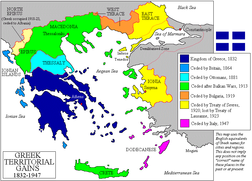
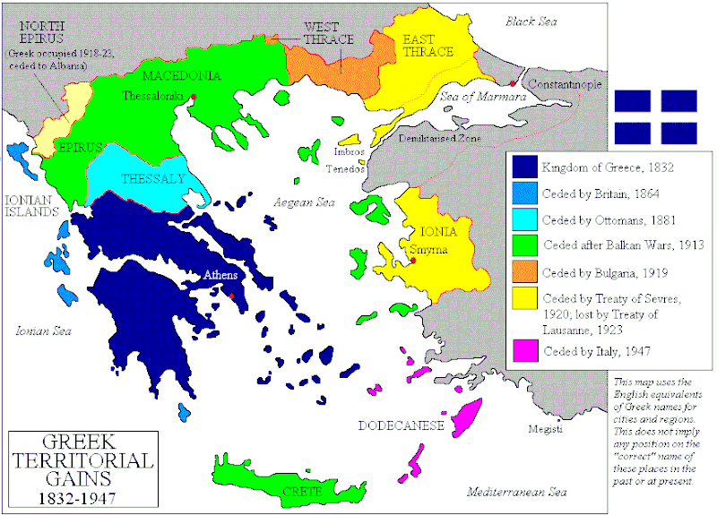
Čeština: Mapa zobrazuje územní expanzi Řeckého království (1832–1947). Dansk: Kort over Grækenlands territoriale udvidelser, 1832-1947. Deutsch: Territoriale Expansion Griechenlands 1832-1947. English: The territorial expansion of Greece, 1832-1947. Español: Mapa de la expansión territorial griega (1832-1947) Euskara: Greziaren lurralde hedapena 1832-1947 bitartean Français : L'expansion territoriale de la Grèce. 1832-1947. Hrvatski: Teritorijalno proširenje Grčke u razdoblju od 1832. do 1947. Italiano: L'espansione territoriale della Grecia dal 1832 al 1947 Magyar: Görögország területi növekedése (1832-1947) Occitan : Evolucions territòrialas de Grècia. Ελληνικά: Η εδαφική επέκταση της Ελλάδας 1832-1947. Македонски: Територијално проширување на Грција Українська: Територіальна експансія Греції (1832-1947). 日本語: ギリシャ王国の版図拡大 (1832-1947年) 中文: 希腊的领土变迁,1832年-1947年间。 العربية : خريطة تُصوِّر الأراضي التي استولت عليها اليونان مُنذُ سنة 1832م حين استقلالها عن الدولة العُثمانيَّة، وُصولًا إلى سنة 1947م |
||||||||
| Sene | |||||||||
| Çeşme | Imported from en:wikipedia by Christophe cagé 09:49, 15 October 2006 (UTC) | ||||||||
| Awtor | en:User:Adam Carr | ||||||||
| Rugsat (Bu faýly täzeden ulanmaklyk) |
I, the copyright holder of this work, hereby publish it under the following licenses:
Islän lisenziýaňyzy saýlap bilersiňiz. |
||||||||
| Beýleki wersiýalar |
Derivative works of this file: Greek history from 1832.GIF
[]
|


.PNG)


.png)


Faýlyň taryhy
Faýlyň geçmişini görmek üçin Sene/Wagt bölümündäki senelere tyklaň.
| Sene/Wagt | Miniatýura | Ölçegler | Ulanyjy | Teswir | |
|---|---|---|---|---|---|
| häzirki | 02:07, 3 ýanwar 2014 | | 868 × 624 (49 KB) | Spesh531 | update the year of Bulgarian losses, 1923 should be 1919 |
| 14:16, 15 iýul 2013 |  | 868 × 624 (28 KB) | Spesh531 | adding Bulgarian losses | |
| 23:23, 18 sentýabr 2011 |  | 868 × 624 (30 KB) | Vasarchit | corrected Epirus borderline | |
| 10:41, 19 sentýabr 2008 |  | 868 × 624 (30 KB) | Peeperman | {{Information |Description= |Source= |Date= |Author= |Permission= |other_versions= }} | |
| 09:50, 15 oktýabr 2006 |  | 868 × 624 (29 KB) | Christophe cagé | ||
| 09:49, 15 oktýabr 2006 |  | 868 × 624 (29 KB) | Christophe cagé | == Summary == Map created by User:Adam Carr, August 2006 - imported from en:wikipedia by ~~~~ == Licensing == {{GFDL-self}} Category:Maps of the history of Greece |
Faýlyň ulanylyşy
Bu faýla çykgydy bar bolan sahypa:
Global faýl ulanyşy
Bu faýl aşakdaky beýleki wikiler tarapyndan ulanylýar:
- az.wikipedia.org sahypasynda ulanyş
- be-tarask.wikipedia.org sahypasynda ulanyş
- be.wikipedia.org sahypasynda ulanyş
- bg.wikipedia.org sahypasynda ulanyş
- br.wikipedia.org sahypasynda ulanyş
- bs.wikipedia.org sahypasynda ulanyş
- ca.wikipedia.org sahypasynda ulanyş
- cv.wikipedia.org sahypasynda ulanyş
- en.wikipedia.org sahypasynda ulanyş
- History of modern Greece
- Macedonia (region)
- Enosis
- Treaty of Sèvres
- Greece–Turkey relations
- History of Greece
- Treaty of Constantinople (1832)
- Portal:Greece
- Talk:Megali Idea
- User talk:Maggas
- User:Adam Carr/My archive of original cartographic contributions
- User talk:Inawe
- Timeline of Eastern Orthodoxy in Greece (1821–1924)
- Greece–Turkey border
- User:Falcaorib
- Talk:Balkan Wars/Archive 1
- User:Biz/Greece-Turkey/background
- Greece–Ottoman Empire relations
- Portal:Greece/sandbox
- et.wikipedia.org sahypasynda ulanyş
- fa.wikipedia.org sahypasynda ulanyş
- fi.wikipedia.org sahypasynda ulanyş
- hy.wikipedia.org sahypasynda ulanyş
- io.wikipedia.org sahypasynda ulanyş
- ka.wikipedia.org sahypasynda ulanyş
- ko.wikipedia.org sahypasynda ulanyş
- ku.wikipedia.org sahypasynda ulanyş
- la.wikipedia.org sahypasynda ulanyş
- lt.wikipedia.org sahypasynda ulanyş
Bu faýlyň global ulanyşyny görkez.