
Faýl:Azerbaijan topographic map-fr.svg

Size of this PNG preview of this SVG file: 757 × 502 piksel. Other resolutions: 320 × 212 piksel | 640 × 424 piksel | 1 024 × 679 piksel | 1 280 × 849 piksel | 2 560 × 1 698 piksel.
Original faýl (SVG faýly, nominal 757 × 502 piksel, faýl ölçegi: 3,07 MB)
Gysgaça düşündiriş
| Düşündiriş |
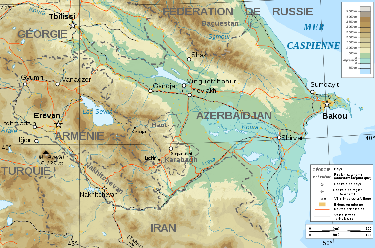
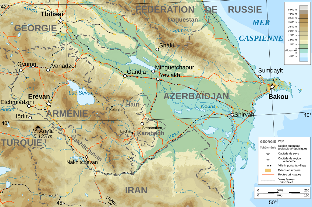
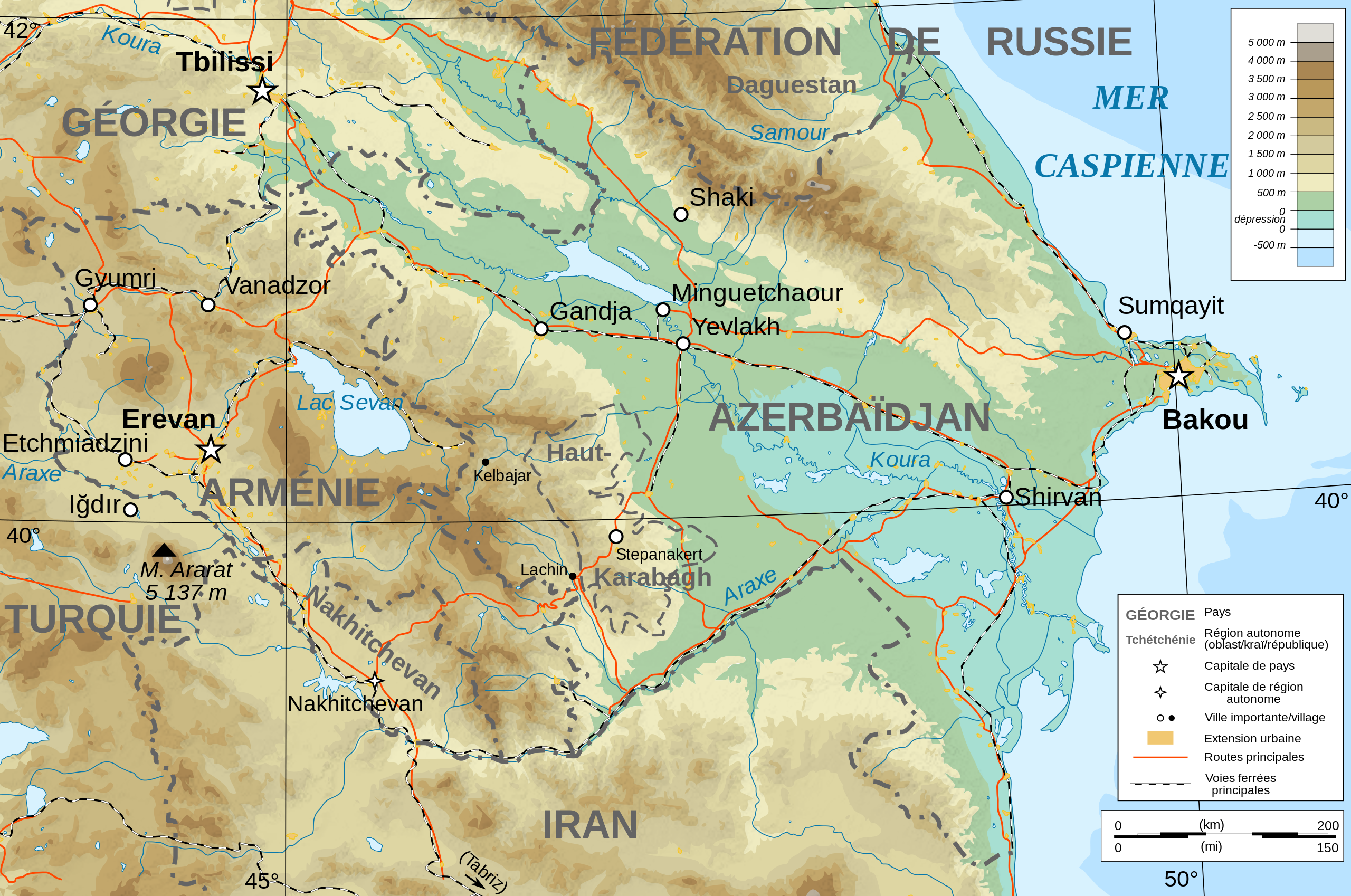
Français : Carte topographique en français de l'Azerbaïdjan et de l'Arménie, avec le Haut-Karabagh en tant que région autonome. |
| Sene | |
| Çeşme |
English: Own work ; Topographic data from the NASA Shuttle Radar Topography Mission (SRTM3 v.2) (public domain) edited with 3DEM, reprojected in UTM with GDAL (GDAL), and vectorized with Inkscape ; UTM projection ; WGS84 datum ; shaded relief (composite image of N-W, W and N lightning positions) ; Reference used for the additional data : * Rivers, cities, railroads, routes, bathymetry : Demis add-on for World Wind (see the approval e-mail and the Demis forum) ; * Borders and coast : World data bank II ; Note : The shaded relief is a raster image embedded in the SVG file. Français : Création personnelle ; Données topographiques de la NASA Shuttle Radar Topography Mission (SRTM3 v.2) (domaine public) éditées avec 3DEM, reprojetées en UTM avec GDAL et vectorisées avec Inkscape ; projection UTM ; WGS84 datum ; relief ombré (image composite d'éclairages du N-O, O et N) ; Références utilisées pour les données complémentaires : * Rivières, villes, chemins de fers, routes, bathymétrie : Demis add-on for World Wind (cf. l'e-mail d'approbation de Demis et le Demis forum) ; * Frontières et côtes : World data bank II ; Note : Le relief ombré est une image bitmap embarquée dans le fichier SVG. |
| Awtor | Bourrichon - fr:Bourrichon) |
| Rugsat (Bu faýly täzeden ulanmaklyk) |
GFDL / Attribution and Share-Alike required |
| Beýleki wersiýalar |
|
| SVG genesis |


Lisenzirleme
I, the copyright holder of this work, hereby publish it under the following licenses:

|
Permission is granted to copy, distribute and/or modify this document under the terms of the GNU Free Documentation License, Version 1.2 or any later version published by the Free Software Foundation; with no Invariant Sections, no Front-Cover Texts, and no Back-Cover Texts. A copy of the license is included in the section entitled GNU Free Documentation License. |
This file is licensed under the Creative Commons Attribution-Share Alike 4.0 International, 3.0 Unported, 2.5 Generic, 2.0 Generic and 1.0 Generic license.
- Siz erkin:
- paýlaşyň – iş göçüriň, paýlaň we gowşuryň
- goşuşdyryp dörediň – iş adaptirläň
- Aşakdaky şertlere laýyklykda:
- salgylanma – Esere awtor ýa-da lisenziýa eýesi tarapyndan görkezilen (ýöne sizi ýa-da eseri ulanmaklygyňyzy goldaýandyklaryny öňe sürmeýän) görnüşde salgylanmalydyr.
- meňzeş paýlaşma – Bu eseri üýtgeden, öwüren ýa-da bu esere esaslanýan başga bir eser döreden ýagdaýyňyzda, emele gelen eser üçin diňe şu ýa-da şuňa meňzeş lisenziýany ulanmak arkaly paýlap bilersiňiz.
Islän lisenziýaňyzy saýlap bilersiňiz.
Faýlyň taryhy
Faýlyň geçmişini görmek üçin Sene/Wagt bölümündäki senelere tyklaň.
| Sene/Wagt | Miniatýura | Ölçegler | Ulanyjy | Teswir | |
|---|---|---|---|---|---|
| häzirki | 18:12, 10 noýabr 2008 | | 757 × 502 (3,07 MB) | Bourrichon | + corr légende |
| 18:07, 10 noýabr 2008 |  | 757 × 502 (3,07 MB) | Bourrichon | + Iğdır | |
| 17:45, 10 noýabr 2008 |  | 757 × 502 (3,06 MB) | Bourrichon | + cities | |
| 17:25, 9 noýabr 2008 |  | 757 × 502 (3,06 MB) | Bourrichon | ||
| 16:36, 8 noýabr 2008 |  | 757 × 502 (3,06 MB) | Bourrichon | == Summary == {{Information |Description={{de|Topographische Karte von Aserbaidschan und Armenien, französische Version}}{{en|Topographic map in French of Azerbaijan and Armenia}}{ |
Faýlyň ulanylyşy
Bu faýly ulanýan hiç hili sahypa ýok.
Global faýl ulanyşy
Bu faýl aşakdaky beýleki wikiler tarapyndan ulanylýar:
- de.wikibooks.org sahypasynda ulanyş
- en.wikipedia.org sahypasynda ulanyş
- eo.wikipedia.org sahypasynda ulanyş
- fi.wikipedia.org sahypasynda ulanyş
- fr.wikipedia.org sahypasynda ulanyş
- pcd.wikipedia.org sahypasynda ulanyş
- ro.wikipedia.org sahypasynda ulanyş
- to.wikipedia.org sahypasynda ulanyş