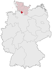
Faýl:Lage des Kreises Pinneberg in Deutschland.png
Lage_des_Kreises_Pinneberg_in_Deutschland.png (176 × 234 piksel, faýlyň ölçegi: 4 KB, MIME tipli: image/png)
Faýlyň taryhy
Faýlyň geçmişini görmek üçin Sene/Wagt bölümündäki senelere tyklaň.
| Sene/Wagt | Miniatýura | Ölçegler | Ulanyjy | Teswir | |
|---|---|---|---|---|---|
| häzirki | 12:21, 5 aprel 2007 |  | 176 × 234 (4 KB) | Ditschi | transparent |
| 09:19, 3 mart 2006 |  | 176 × 234 (4 KB) | Rauenstein | Karte erstellt auf der Grundlage der opengeodb.de-Umrisse - GNU-FDL Geograv 00:54, 31. Dez 2004 {{Bild-GFDL}} Category:Maps of Germany |
Faýlyň ulanylyşy
Bu faýla çykgydy bar bolan sahypa:
Global faýl ulanyşy
Bu faýl aşakdaky beýleki wikiler tarapyndan ulanylýar:
- ace.wikipedia.org sahypasynda ulanyş
- am.wikipedia.org sahypasynda ulanyş
- ang.wikipedia.org sahypasynda ulanyş
- arc.wikipedia.org sahypasynda ulanyş
- av.wikipedia.org sahypasynda ulanyş
- ay.wikipedia.org sahypasynda ulanyş
- bcl.wikipedia.org sahypasynda ulanyş
- bi.wikipedia.org sahypasynda ulanyş
- bm.wikipedia.org sahypasynda ulanyş
- bpy.wikipedia.org sahypasynda ulanyş
- bxr.wikipedia.org sahypasynda ulanyş
- cbk-zam.wikipedia.org sahypasynda ulanyş
- ceb.wikipedia.org sahypasynda ulanyş
- ch.wikipedia.org sahypasynda ulanyş
- cr.wikipedia.org sahypasynda ulanyş
- cs.wikipedia.org sahypasynda ulanyş
- cu.wikipedia.org sahypasynda ulanyş
- cv.wikipedia.org sahypasynda ulanyş
- cy.wikipedia.org sahypasynda ulanyş
- dsb.wikipedia.org sahypasynda ulanyş
- dv.wikipedia.org sahypasynda ulanyş
- dz.wikipedia.org sahypasynda ulanyş
- eml.wikipedia.org sahypasynda ulanyş
- eo.wikipedia.org sahypasynda ulanyş
- es.wikipedia.org sahypasynda ulanyş
- ext.wikipedia.org sahypasynda ulanyş
- ff.wikipedia.org sahypasynda ulanyş
- fiu-vro.wikipedia.org sahypasynda ulanyş
- fj.wikipedia.org sahypasynda ulanyş
- fo.wikipedia.org sahypasynda ulanyş
- frp.wikipedia.org sahypasynda ulanyş
- frr.wikipedia.org sahypasynda ulanyş
- fr.wikipedia.org sahypasynda ulanyş
- fur.wikipedia.org sahypasynda ulanyş
- fy.wikipedia.org sahypasynda ulanyş
- gag.wikipedia.org sahypasynda ulanyş
- gn.wikipedia.org sahypasynda ulanyş
- got.wikipedia.org sahypasynda ulanyş
- hak.wikipedia.org sahypasynda ulanyş
- haw.wikipedia.org sahypasynda ulanyş
- hif.wikipedia.org sahypasynda ulanyş
- hi.wikipedia.org sahypasynda ulanyş
- hr.wikipedia.org sahypasynda ulanyş
- ht.wikipedia.org sahypasynda ulanyş
- hy.wikipedia.org sahypasynda ulanyş
- id.wikipedia.org sahypasynda ulanyş
- ie.wikipedia.org sahypasynda ulanyş
Bu faýlyň global ulanyşyny görkez.

