
Faýl:Comoros (orthographic projection).svg

Size of this PNG preview of this SVG file: 550 × 550 piksel. Other resolutions: 240 × 240 piksel | 480 × 480 piksel | 768 × 768 piksel | 1 024 × 1 024 piksel | 2 048 × 2 048 piksel.
Original faýl (SVG faýly, nominal 550 × 550 piksel, faýl ölçegi: 185 KB)
Gysgaça düşündiriş
| Düşündiriş |
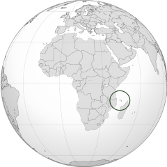
English: Orthographic map of the Comoros |
| Sene | |
| Çeşme | Öz işi (eseri) |
| Awtor | Spesh531 |
| Beýleki wersiýalar |
Derivative works of this file: Africa (orthographic projection).svg .svg) |
.svg)
.svg)
.svg)
.svg)
.svg)
.svg)
.svg)
.svg)
.svg)
.svg)
.svg)
.svg)
.svg)
.svg)
.svg)
.svg)
.svg)
.svg)
.svg)
.svg)
.svg)
.svg)
.svg)
.svg)
.svg)
.svg)
.svg)
.svg)
.svg)
.svg)
.svg)
.svg)
.svg)
.svg)
.svg)
.svg)
.svg)
.svg)
.svg)
.svg)
.svg)
.svg)
.svg)
.svg)
.svg)
.svg)
.svg)
.svg)
.svg)
.svg)
.svg)
.svg)
.svg)
.svg)
.svg)
.svg)
.svg)
.svg)
.svg)
.svg)
.svg)
.svg)
.svg)
.svg)
.svg)
.svg)
.svg)
.svg)
.svg)
.svg)
.svg)
.svg)
.svg)

.svg)

.svg)

.svg)
.svg)
.svg)
.svg)
.svg)
.svg)
.svg)


.svg)
.svg)
.svg)
.svg)
.svg)
.svg)
.svg)

.svg)
.svg)
.svg)
.svg)
.svg)
.svg)
.svg)
.svg)
.svg)

.svg)
.svg)
.svg)
.svg)
.svg)
.svg)
.svg)
_without_national_boundaries.svg)
.svg)
.svg)
.svg)
.svg)
.svg)
.svg)

.svg)
.svg)
.png)
.svg)
.svg)
.svg)
.svg)

.svg)
.svg)
.svg)
.svg)
.svg)
.svg)
.svg)
.svg)
.svg)
.svg)
.svg)

.svg)
.svg)
.svg)
.svg)
.svg)
.svg)
.svg)
.svg)
.svg)

.svg)
.svg)

.svg)
.svg)
.svg)
.svg)
.svg)
.svg)
.svg)
.svg)
.svg)
.svg)
.svg)
.svg)
.svg)
.svg)
.svg)
.svg)
.svg)
.svg)
.svg)
.svg)
.svg)
.svg)
.svg)
.svg)
.svg)
.svg)
.svg)
_-_Crimea_disputed.svg)
.svg)
.svg)
.svg)
.svg)
.svg)
.svg)
.svg)
.svg)
.svg)
.svg)
.svg)
_political.svg)
.svg)
.svg)
.svg)
.svg)
_-_Crimea_disputed_-_no_borders.svg)
.svg)
.svg)
.svg)
.svg)
.svg)
.svg)
.svg)
.svg)
.svg)
.svg)
.svg)

.svg)
.svg)
.svg)

.png)
.svg)
.svg)
.svg)
.svg)
.svg)
.svg)
.svg)
.svg)
.svg)
.svg)
.svg)
.svg)
.svg)
.svg)
.svg)
.svg)
.svg)
.svg)
.svg)
.svg)
.svg)
.svg)
.svg)
.svg)
.svg)
.svg)
.svg)
.svg)
.svg)
.svg)
.svg)
.svg)
.svg)
.svg)
.png)
.svg)
.svg)
.svg)
_(orthographic_projection).png)
.svg)
| Camera location | | View this and other nearby images on: OpenStreetMap |
|---|
.svg¶ms=000.000000_N_0015.000000_E_globe:Earth_type:camera_type:satellite_&language=tk)
Lisenzirleme
I, the copyright holder of this work, hereby publish it under the following licenses:
Bu faýl Creative Commons Attribution-Share Alike 3.0 Unported lisenziýasyna laýyklykda lisenzirlenendir.
- Siz erkin:
- paýlaşyň – iş göçüriň, paýlaň we gowşuryň
- goşuşdyryp dörediň – iş adaptirläň
- Aşakdaky şertlere laýyklykda:
- salgylanma – Esere awtor ýa-da lisenziýa eýesi tarapyndan görkezilen (ýöne sizi ýa-da eseri ulanmaklygyňyzy goldaýandyklaryny öňe sürmeýän) görnüşde salgylanmalydyr.
- meňzeş paýlaşma – Bu eseri üýtgeden, öwüren ýa-da bu esere esaslanýan başga bir eser döreden ýagdaýyňyzda, emele gelen eser üçin diňe şu ýa-da şuňa meňzeş lisenziýany ulanmak arkaly paýlap bilersiňiz.

|
Permission is granted to copy, distribute and/or modify this document under the terms of the GNU Free Documentation License, Version 1.2 or any later version published by the Free Software Foundation; with no Invariant Sections, no Front-Cover Texts, and no Back-Cover Texts. A copy of the license is included in the section entitled GNU Free Documentation License. |
Islän lisenziýaňyzy saýlap bilersiňiz.
Faýlyň taryhy
Faýlyň geçmişini görmek üçin Sene/Wagt bölümündäki senelere tyklaň.
| Sene/Wagt | Miniatýura | Ölçegler | Ulanyjy | Teswir | |
|---|---|---|---|---|---|
| häzirki | 16:28, 29 iýun 2012 | | 550 × 550 (185 KB) | Spesh531 | == {{int:filedesc}} == {{Information |Description={{en|1=Orthographic map of the Comoros}} |Source={{own}} |Author=Spesh531 |Date=2012-06-29 |Permission= |other_versions={{DerivativeVersions|Africa (orthographic projection).svg}} {{Gr... |
Faýlyň ulanylyşy
Bu faýla çykgydy bar bolan sahypa:
Global faýl ulanyşy
Bu faýl aşakdaky beýleki wikiler tarapyndan ulanylýar:
- ar.wikipedia.org sahypasynda ulanyş
- arz.wikipedia.org sahypasynda ulanyş
- ast.wikipedia.org sahypasynda ulanyş
- avk.wikipedia.org sahypasynda ulanyş
- az.wikipedia.org sahypasynda ulanyş
- bg.wikipedia.org sahypasynda ulanyş
- bi.wikipedia.org sahypasynda ulanyş
- ca.wikipedia.org sahypasynda ulanyş
- cdo.wikipedia.org sahypasynda ulanyş
- ce.wikipedia.org sahypasynda ulanyş
- chr.wikipedia.org sahypasynda ulanyş
- cs.wikipedia.org sahypasynda ulanyş
- dag.wikipedia.org sahypasynda ulanyş
- de.wikivoyage.org sahypasynda ulanyş
- diq.wikipedia.org sahypasynda ulanyş
- el.wikipedia.org sahypasynda ulanyş
- en.wikipedia.org sahypasynda ulanyş
- en.wikinews.org sahypasynda ulanyş
- es.wikipedia.org sahypasynda ulanyş
- eu.wikipedia.org sahypasynda ulanyş
- fa.wikivoyage.org sahypasynda ulanyş
- fi.wikivoyage.org sahypasynda ulanyş
- fo.wikipedia.org sahypasynda ulanyş
- fr.wikipedia.org sahypasynda ulanyş
- fr.wikinews.org sahypasynda ulanyş
- ga.wikipedia.org sahypasynda ulanyş
- gcr.wikipedia.org sahypasynda ulanyş
- gl.wikipedia.org sahypasynda ulanyş
- gn.wikipedia.org sahypasynda ulanyş
- hak.wikipedia.org sahypasynda ulanyş
- ha.wikipedia.org sahypasynda ulanyş
- he.wikipedia.org sahypasynda ulanyş
- ht.wikipedia.org sahypasynda ulanyş
- ia.wikipedia.org sahypasynda ulanyş
- id.wikipedia.org sahypasynda ulanyş
- ie.wikipedia.org sahypasynda ulanyş
- incubator.wikimedia.org sahypasynda ulanyş
Bu faýlyň global ulanyşyny görkez.
.svg)
.svg)