
Faýl:Be-map.png

Wersiýanyň mundan uly ölçegi ýok.
Be-map.png (559 × 600 piksel, faýlyň ölçegi: 176 KB, MIME tipli: image/png)

|
This locator map image could be re-created using vector graphics as an SVG file. This has several advantages; see Commons:Media for cleanup for more information. If an SVG form of this image is available, please upload it and afterwards replace this template with
{{vector version available|new image name}}.
It is recommended to name the SVG file “Be-map.svg”—then the template Vector version available (or Vva) does not need the new image name parameter. |
Gysgaça düşündiriş
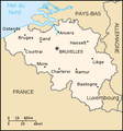
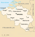
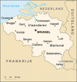
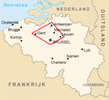
| Düşündiriş | Belgium map from CIA World Factbook (since 8 maý 2006), converted from original GIF format |
| Sene | |
| Çeşme |
CIA World Factbook |
| Awtor | United States Central Intelligence Agency |
| Beýleki wersiýalar |
|
.png)
Lisenzirleme
This image is in the public domain because it contains materials that originally came from the United States Central Intelligence Agency's World Factbook.
|
 |
Derivative works
Derivatives of 2006 map:


Derivatives of 2004 map:


Derivatives of 2000 map:
-
 Belgie-mapa.PNG
čeština -
 Be-map-eo.png
Esperanto -
 Be-map-es.png
español -
 Be-map-fr.png
français -
 Be-map-nl.png
Nederlands -
 Belgium-map-nl.png
Nederlands -
 Belgium üres.png
 -
 Ath in Belgium.png
 -
 Dendermonde location map.png
 -
 Vlaamse ruit.png


Faýlyň taryhy
Faýlyň geçmişini görmek üçin Sene/Wagt bölümündäki senelere tyklaň.
| Sene/Wagt | Miniatýura | Ölçegler | Ulanyjy | Teswir | |
|---|---|---|---|---|---|
| häzirki | 21:48, 13 aprel 2020 | | 559 × 600 (176 KB) | Le Fou | Zeebrugge is not a city, but part of the city of Bruges. |
| 19:13, 21 iýul 2018 |  | 1 024 × 1 099 (24 KB) | Karel Adriaan | Resized to 1024 | |
| 20:48, 20 aprel 2007 |  | 328 × 353 (12 KB) | Tene~commonswiki | Optimised (0) | |
| 17:07, 11 mart 2007 |  | 328 × 353 (13 KB) | Feydey | 2007 factbook map | |
| 13:55, 27 maý 2006 |  | 329 × 353 (20 KB) | Matt314 | "Redu" in the same font size as the other cities | |
| 20:59, 7 aprel 2006 |  | 329 × 353 (20 KB) | Abrev | Map of Belgium Updated version uploaded by [http://de.wikipedia.org/wiki/Benutzer:Tzzzpfff]. No rights reserved for updating. | |
| 16:46, 5 ýanwar 2006 |  | 330 × 355 (9 KB) | Jrenier | Reverted to earlier revision | |
| 16:35, 5 ýanwar 2006 |  | 330 × 355 (9 KB) | Jrenier | Reverted to earlier revision | |
| 19:53, 3 ýanwar 2006 |  | 330 × 355 (28 KB) | Iunity | ||
| 19:24, 27 noýabr 2004 |  | 330 × 355 (9 KB) | Kneiphof | Map of Belgium, CIA factbook (taken from EN Wikipedia) |
Faýlyň ulanylyşy
Bu faýla çykgydy bar bolan sahypa:
Global faýl ulanyşy
Bu faýl aşakdaky beýleki wikiler tarapyndan ulanylýar:
- als.wikipedia.org sahypasynda ulanyş
- ay.wikipedia.org sahypasynda ulanyş
- azb.wikipedia.org sahypasynda ulanyş
- az.wikipedia.org sahypasynda ulanyş
- bcl.wikipedia.org sahypasynda ulanyş
- be-tarask.wikipedia.org sahypasynda ulanyş
- bg.wiktionary.org sahypasynda ulanyş
- bn.wikipedia.org sahypasynda ulanyş
- bs.wikipedia.org sahypasynda ulanyş
- ca.wikipedia.org sahypasynda ulanyş
- de.wikipedia.org sahypasynda ulanyş
- de.wikinews.org sahypasynda ulanyş
- dsb.wikipedia.org sahypasynda ulanyş
- en.wikipedia.org sahypasynda ulanyş
- en.wikinews.org sahypasynda ulanyş
- en.wikivoyage.org sahypasynda ulanyş
- en.wiktionary.org sahypasynda ulanyş
- es.wikipedia.org sahypasynda ulanyş
- fa.wikipedia.org sahypasynda ulanyş
- fi.wikipedia.org sahypasynda ulanyş
- fr.wikipedia.org sahypasynda ulanyş
- fr.wikinews.org sahypasynda ulanyş
- gag.wikipedia.org sahypasynda ulanyş
- ga.wikipedia.org sahypasynda ulanyş
- gl.wikipedia.org sahypasynda ulanyş
- ha.wikipedia.org sahypasynda ulanyş
- hi.wikipedia.org sahypasynda ulanyş
- hy.wikipedia.org sahypasynda ulanyş
- incubator.wikimedia.org sahypasynda ulanyş
- io.wikipedia.org sahypasynda ulanyş
Bu faýlyň global ulanyşyny görkez.